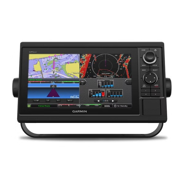
GPSMAP 1022 is designed for cruisers, sailors and sailing racers who need the advanced all-in-1 solution provided by our 10-inch keyed chartplotter. Features a large, bright screen coupled with a quick and easy-to-use keypad interface with user-programmable keys and a multifunction control knob. Features 10-inch color display with keypad interface and multifunction control knob. High-sensitivity internal 10 Hz GPS and GLONASS receiver. Fully network capable for Garmin Marine Network and NMEA 2000 plus NMEA 0183 support. Supports optional BlueChart g3 Vision premium charts. Garmin Marine Network support allows sharing of sonar, maps, user data, dome or open-array radar, IP cameras and Panoptix sonar among multiple units. Includes NMEA 2000 network connectivity and NMEA 0183 support for autopilots, digital switching, weather, FUSION-Link, VHF, AIS and other sensors. Built in Wi-Fi gives you access to the free all-in-one ActiveCaptain app, so you can manage your marine experience from nearly anywhere. If you have waypoints, tracks or frequently used routes stored on another manufacturers GPS product or on a Garmin handheld device its easy to transfer those items to your new Garmin chartplotter via industry-standard GPX software formatting. What’s in the box: GPSMAP 1022 Chartplotter, power/data cable, NMEA 2000 T-connector, NMEA 2000 drop cable (2 m), bail mount kit with knobs, flush mount kit with gasket, protective cover, trim piece snap covers and documentation. Specifications for Garmin GPSMAP 1022, non-sonar, Worldwide: Manufacturer: Garmin Display Resolution: 1024×600 pixels Additional Features: Worldwide Basemap, no Sonar, no Transducer Water Resistance Level: IPX-7 Weight: 4.1 lb Size: 10 in Color: Black Features of Garmin GPSMAP 1022, non-sonar, Worldwide General Physical dimensions:12.5″ x 7.3″ x 2.7″ (318 x 185 x 69 mm) Display size:8.8″ x 4.9″ (224 x 125 mm) Display resolution:1024 x 600 pixels Display type:WSVGA display Weight:4.1 lbs (1.85 kg) Water rating:IPX7 Power consumption:Max power usage at 10 Vdc: 32.4 W Typical current draw at 12 Vdc: 1.9 A Max current draw at 12 Vdc: 2.7 A Antenna:Internal or external over NMEA 2000 Mounting options:Bail or flush Receiver:10 Hz high-sensitivity Garmin Marine Network ports:2 Maps & Memory Preloaded maps:None Accepts data cards:2 SD cards Waypoints:5,000 Routes:100 Track log:50,000 points; 50 saved tracks Package Contents: Garmin GPSMAP 1022, non-sonar, Worldwide GPSMAP 1022 chartplotter Power/data cable NMEA 2000 T-connector NMEA 2000 drop cable (2 m) Bail mount kit with knobs Flush mount kit with gasket Protective cover Trim piece snap covers Documentation


MAECENAS IACULIS
Vestibulum curae torquent diam diam commodo parturient penatibus nunc dui adipiscing convallis bulum parturient suspendisse parturient a.Parturient in parturient scelerisque nibh lectus quam a natoque adipiscing a vestibulum hendrerit et pharetra fames nunc natoque dui.
ADIPISCING CONVALLIS BULUM
- Vestibulum penatibus nunc dui adipiscing convallis bulum parturient suspendisse.
- Abitur parturient praesent lectus quam a natoque adipiscing a vestibulum hendre.
- Diam parturient dictumst parturient scelerisque nibh lectus.
Scelerisque adipiscing bibendum sem vestibulum et in a a a purus lectus faucibus lobortis tincidunt purus lectus nisl class eros.Condimentum a et ullamcorper dictumst mus et tristique elementum nam inceptos hac parturient scelerisque vestibulum amet elit ut volutpat.



Reviews
There are no reviews yet.